

Unlocking the Skies: When Does a Listing Actually Need Drone Photography?
WHY PAY MORE?
Unlocking the Skies: When Does a Listing Actually Need Drone Photography?
Drone photography is one of the most visually striking tools in real estate marketing. It's also one of the most misused. Here's an honest guide to when aerial photography genuinely moves listings — and when it's money better spent elsewhere.
There's a moment in almost every real estate conversation when someone suggests drone photography. The agent nods. The seller likes the idea. It sounds impressive. And sometimes it is — genuinely, measurably impressive in ways that affect how fast a home sells and for how much.
But drone photography isn't a universal upgrade. Used on the wrong property, it can highlight problems rather than strengths. A cramped urban lot surrounded by other cramped urban lots doesn't become more appealing from 200 feet in the air. A modest ranch on a busy street doesn't get prettier with an aerial perspective. The sky view just confirms what buyers already suspected.
The agents and sellers who get the most out of aerial real estate photography are the ones who understand exactly what it does — and what it doesn't. This is that guide.
What drone photography shows that ground photography can't
Ground photography is excellent at showing what's inside a home and how it presents from the street. What it cannot show is context — the relationship between the property and everything around it. That's where aerial photography earns its place.
From the air, a buyer can see lot size and shape in a way no ground shot conveys. They can see how close the home sits to a lake, a golf course, a nature preserve, or a highway. They can understand the neighborhood layout, the proximity to amenities, and the scale of the land relative to the structure. For properties where those factors are selling points, aerial photography doesn't just add a nice visual — it makes the case that the listing description can't fully make on its own.
This is also where screen appeal starts before buyers ever walk in the door — the aerial shot is often the first image in a listing gallery, and it sets the emotional tone for everything that follows. Get it right and buyers arrive at the ground-level photos already excited. Get it wrong and you've led with your weakest asset.
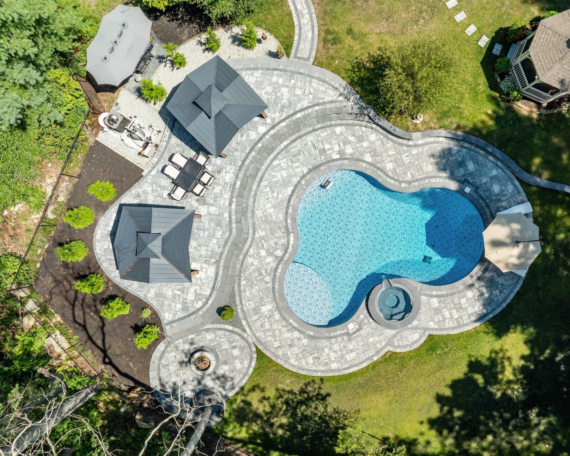
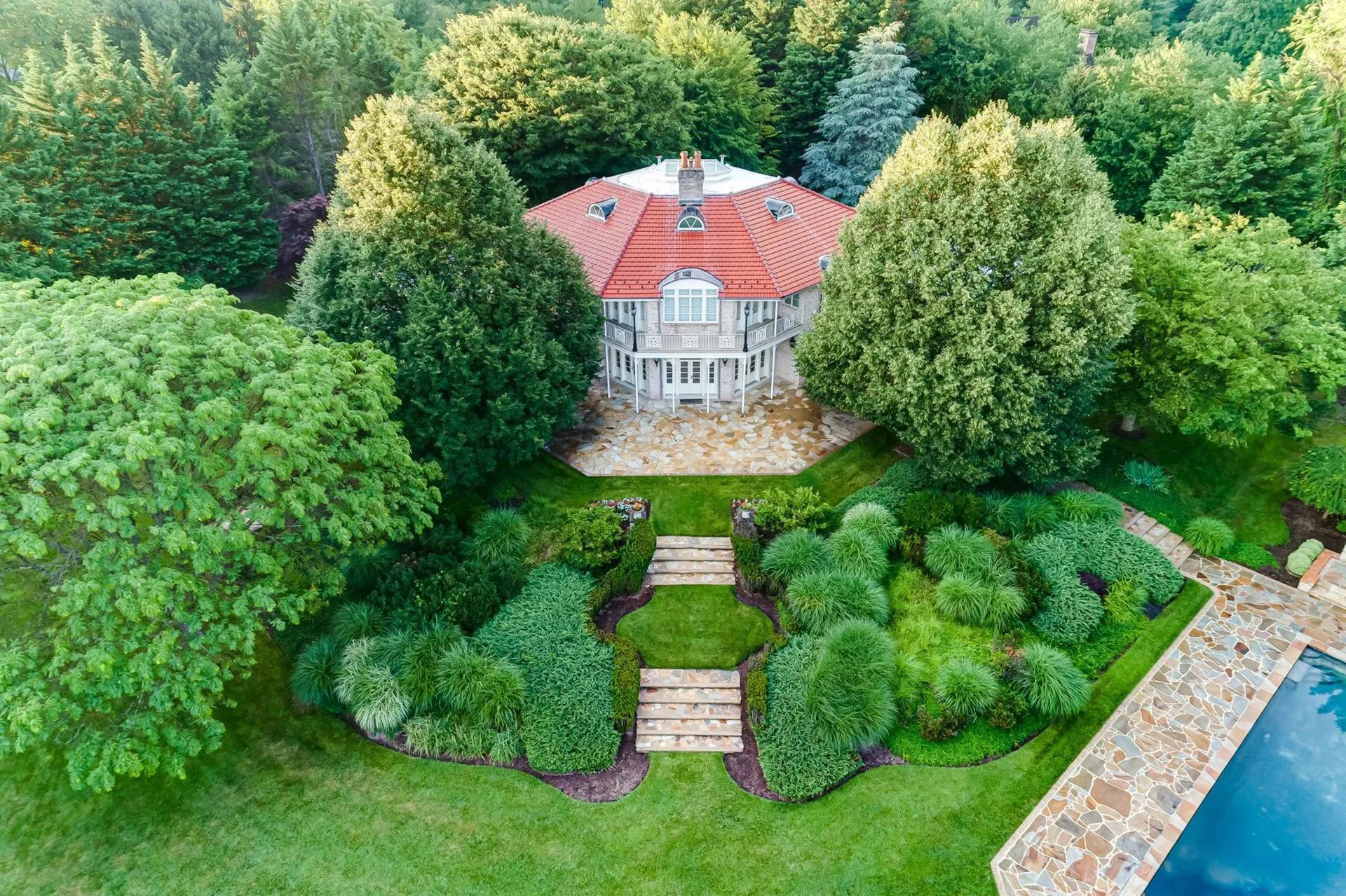
The properties that actually need drone photography
Not every listing. But for these property types, aerial photography isn't optional — it's the difference between a listing that tells its full story and one that undersells itself.
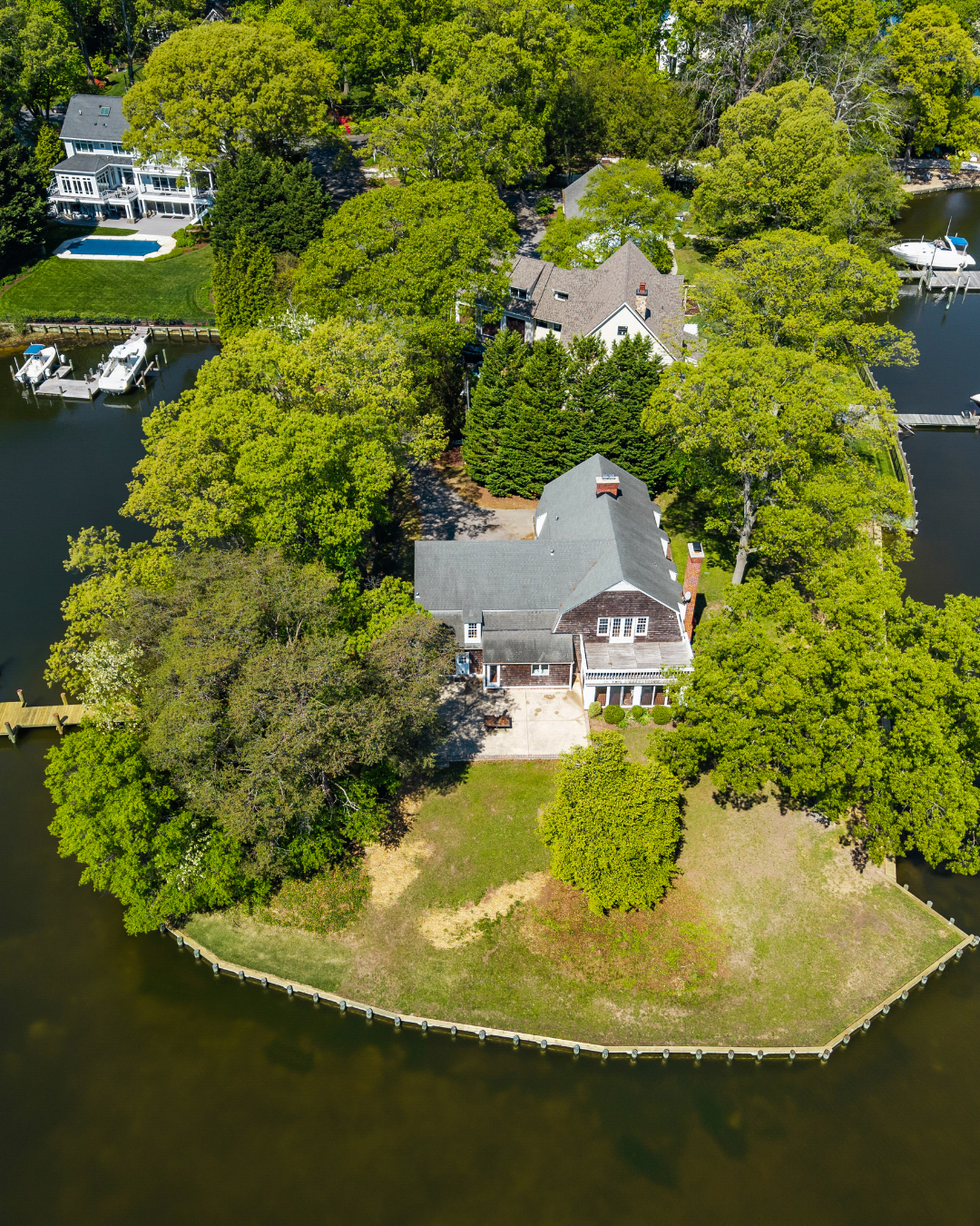
Waterfront and water-view properties
This is the clearest case for drone photography in real estate. A waterfront property photographed only from the ground is a listing that's hiding its primary selling point. The water view, the dock, the relationship between the home and the shoreline — none of that reads from street level the way it reads from above. Aerial photography for waterfront listings isn't a premium add-on. It's a basic requirement for honest, effective marketing.
Acreage, farms, and large lot listings
When a property's land is part of its value, buyers need to see that land. A five-acre property photographed at ground level looks like any other yard. From the air, the scale becomes real — the pastures, the outbuildings, the treelines, the boundaries. For farms, ranches, equestrian properties, and large residential lots, aerial photography is how you sell what you're actually selling. Aerial photography's direct impact on closing rates is most pronounced in this property category precisely because the land itself is the product.
Golf course and resort-adjacent properties
A home that backs up to a golf course fairway, a nature preserve, or a resort amenity has a location story that only aerial photography can tell completely. The green views, the open space, the privacy — these are features buyers are paying a premium for. Drone photography makes them visible in a single frame.
Architecturally distinctive homes
Some homes are designed to be seen from above. Rooflines with complex geometry, courtyard layouts, properties with significant landscaping architecture, or homes whose footprint tells a design story — these benefit enormously from aerial perspective. Ground photography can show individual elements; drone photography shows how they compose together.
Commercial and investment properties
For commercial real estate — retail centers, office complexes, industrial properties, multi-family developments — aerial photography is standard practice. Buyers and investors need to assess parking, access points, surrounding infrastructure, and proximity to major roads or transit. Commercial real estate photography without an aerial component is leaving critical decision-making information out of the listing.
New construction and development sites
Pre-construction and development marketing relies heavily on aerial photography because the finished product doesn't exist yet. Drone shots showing the site, the surrounding neighborhood, the proximity to amenities, and the scale of the development give buyers and investors the context they need to make decisions based on potential rather than current condition.
When drone photography doesn't help — and can hurt
This is the section most drone photography articles skip. The honest answer is that aerial photography is the wrong tool for a significant percentage of listings — and using it anyway wastes budget and can actively undermine a listing's presentation.
The agents who earn the most trust are the ones who give sellers an honest assessment — not a default recommendation to add every service to the package. Understanding when to recommend against drone photography is as important as understanding when to recommend it.
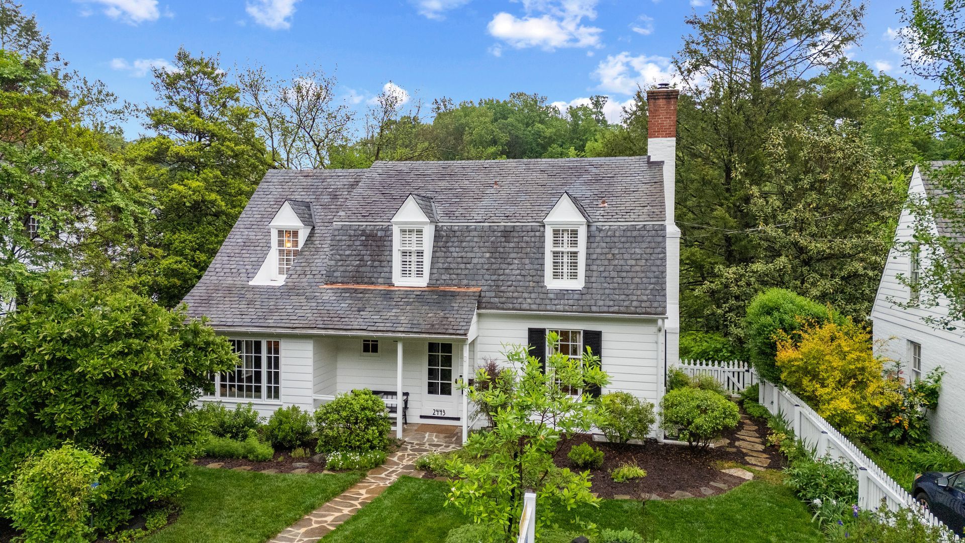
- 01 Small urban and suburban lots with dense surrounding development. When every home on the block looks the same from above and the lot offers no distinguishing features, aerial photography provides no selling advantage. Worse, it can reveal how close the neighbors are, how little yard exists, or how the property sits relative to commercial infrastructure nearby.
- 02 Properties near unattractive surroundings. A home that's a block from a highway, adjacent to a commercial strip, or near infrastructure that looks worse from above than it does at street level should not lead with aerial photography. The drone tells the truth — which is sometimes not the truth you want buyers seeing first.
- 03 Entry-level and mid-market homes where the budget is better spent elsewhere. Professional ground photography, virtual staging, and a 3D virtual tour will generate more buyer engagement on most standard residential listings than aerial photography. The drone budget is better invested in the visual assets buyers actually use to make decisions.
- 04 Properties with deferred exterior maintenance. Aerial photography reveals roof condition, gutter issues, faded paint, and overgrown landscaping with an honesty that street-level photography often softens. If the exterior needs work, the drone can make disclosure complications worse, not better.
FAA rules, no-fly zones, and what sellers need to know
This is where professional drone photography separates itself from someone flying a consumer drone over a listing. Commercial drone operations in the United States require FAA Part 107 certification — a written aeronautical knowledge test that covers airspace classification, weather, operations, and emergency procedures. Any drone photographer operating commercially without this certification is flying illegally.
Beyond certification, airspace matters. Controlled airspace around airports, military installations, stadiums, and national parks requires authorization before a flight can legally take place. The FAA's LAANC system allows certified operators to request airspace authorization digitally — often in seconds. Before booking any drone shoot, sellers and agents should confirm their photographer is Part 107 certified and has verified airspace clearance for the property location.
Florida properties near NAS Jacksonville, Cecil Airport, St. Augustine Airport, and other regional facilities require particular attention to airspace. A professional drone photographer knows how to check these restrictions and obtain the necessary authorizations — and the FAA fines for unauthorized commercial drone operations can reach $32,666 per violation.
Knowing how to choose the right drone photographer starts with verifying their Part 107 certification and understanding their airspace authorization process. Those two questions alone separate professionals from people with a drone and a social media account.
What good drone photography looks like — and what bad drone photography costs you
Drone photography has a low floor and a high ceiling. The equipment is accessible. The skills required to execute it well are not. The difference between a drone shot that generates immediate buyer interest and one that quietly undermines the listing comes down entirely to the operator's judgment — not the hardware.
Light, altitude, timing, composition, and post-processing are the variables that determine whether aerial photography earns its place in a listing. Get any one of them wrong and the result ranges from unremarkable to actively harmful.
- 01 Wrong time of day. Harsh midday sun flattens aerial photography and burns out rooftops and landscaping. The best drone shots are captured during golden hour — the hour after sunrise or before sunset — when light is directional, shadows are long, and colors are warm.
- 02 Wrong altitude and angle. High enough to show context and scale, low enough that the home remains the focal point. Too high and the property disappears into a map. Too low and you have an awkward rooftop shot. The six elements that separate average drone shots from exceptional ones come down to deliberate compositional decisions, not just flying up and pressing record.
- 03 Blown-out or flat skies. A gray, overcast sky in an aerial shot makes a property look dull regardless of how good the home and lot are. Professional drone photographers either shoot at the right time or apply sky replacement in post-processing to deliver the visual impact the listing deserves.
- 04 Shaky or poorly edited video footage. Drone video should be cinematic — smooth, deliberate movements that reveal the property progressively. The fundamentals of effective drone shot planning are about timing, composition, and post-processing — not just having access to the equipment.
How drone photography fits into the complete visual stack
Drone photography is one layer in a complete visual marketing system — not a replacement for any other layer, and not effective in isolation. The listings that perform best combine every visual asset into a coherent presentation that gives buyers everything they need to make a confident decision before scheduling a showing.
Professional ground photography establishes the home's interior and exterior presentation. A 3D virtual tour lets buyers navigate the space. An interactive floor plan gives them the logical framework. Virtual staging removes the perceptual friction of vacant or dated spaces. And drone photography — when the property warrants it — adds the aerial context that makes the full picture complete.
The discipline is knowing which assets each specific property actually needs. That's the difference between a complete real estate listing marketing strategy and a checklist of services someone ran through without thinking.
According to Zillow's research, homes that sell within seven days are 2.6 times more likely to go above asking price. The listings that earn that seven-day window are the ones where every visual decision was made intentionally — including the decision about whether to fly a drone.
Where drone photography is headed
The technology is evolving faster than most sellers and agents realize. FPV drones are already changing how listings are filmed — creating immersive, cinematic fly-through footage that moves through a property from exterior to interior in a single continuous shot. What used to require a helicopter and a film crew now happens with a palm-sized drone and a skilled pilot.
Drone mapping technology is creating detailed 3D models of properties and land parcels from aerial data — giving buyers and investors spatial information that goes beyond what any photograph can convey. For large acreage listings, development sites, and commercial properties, drone mapping is becoming a standard due-diligence tool, not just a marketing asset.
AI-assisted flight planning, automated editing, and real-time airspace monitoring are making professional drone photography faster and more reliable. But the fundamentals don't change: the best aerial photography still requires a skilled operator who understands light, composition, and the specific story a property needs to tell.
The bottom line
Drone photography earns its place when a property has an aerial story worth telling — land, water, architecture, location context, or scale that ground photography simply cannot convey. For those properties, it's one of the highest-impact visual investments a seller can make.
For properties where the aerial view doesn't add to the story — or worse, detracts from it — the budget is better directed at the visual assets that actually drive buyer engagement: professional photography, virtual staging, 3D tours, and interactive floor plans.
The question was never whether drone photography is impressive. It is. The question is whether it's right for your listing. Answer that honestly before the drone goes up, and the rest follows naturally.